


Navigating the Big Smoke with Nokia Ovi Maps
By Gadjo Cardenas Sevilla
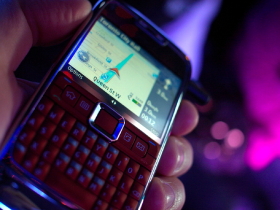
Nokia's recent "Map it Out Challenge" saw members of the media armed with Nokia E71 smartphones running on Telus new HSPA+ network. Gadjo Sevilla was on hand to check it out.
recent "Map it Out Challenge" offered a hands on demonstration of Nokia's Ovi Maps 3.0, the application used in a scavenger-like hunt for landmarks in downtown Toronto.
Ovi Maps 3.0 is Nokia's integrated mobile suite that offers free mapping through data and GPS connections. It also offers turn-by-turn navigation as well as live traffic updates, but as additional subscription-based services. Navigation is set to cost $9.29 a month while access to live traffic feeds will be $3.49 extra per month for Telus subscribers.
Rogers also offers the Nokia E71 smartphone that comes with an older but upgradable version of Ovi Maps.
Powered by navigation and mapping technology from Navteq, which Nokia recently acquired for $8.1 Billion, Ovi maps brings a lot of sophisticated features to relatively slim and lightweight handsets like the E71.
The Ovi Map 3.0 features, which are standard in standalone GPS units, include a choice of viewing angles, 3D depiction of popular buildings and landmarks, detailed descriptions and location-based information and the ability to bookmark, upload and share favored places and routes.
Ovi Maps also offers a comprehensive collection of international downloadable maps, a convenient option for travelers who want to find their way abroad.
On the road, we found the Ovi Map service worked well, even while inside a moving bus with limited line-of-sight to satellites. Searching for an address and then getting directions to it from your current location was straightforward.
The application might not replace car-based and standalone GPS devices, but it's probably a good backup solution. The phone's 320 x 240 pixel, 2.36 inch screen is a little on the small side compared to dedicated GPS devices, but the functionality was equivalent.
Speaking of which, using pedestrian mode was sometimes a challenge as it was tricky to get a fix on the satellite signals on a cloudy day surrounded by high-rise buildings, a common limitation of most GPS devices.
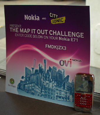
The "Map it Out Challenge," brought participants from Nathan Philips Square to the Eaton Centre then to Massey Hall and finally to the Hard Rock Café at Yonge and Dundas Square.
Each checkpoint required answering questions on local music and trivia through City Sonic's application - a Toronto-based company that Sonic develops location-based films and applications, where points of interest in a map can launch short videos about that neighborhood and particular musicians in the area.

Ovi Maps will be partnering with more content providers in the hopes of adding a richer media experience to their mapping applications.
 Gadjo Cardenas Sevilla
Reader Comments