Entries in Apple Maps (18)

Friday
Dec152017

Apple Maps adds detailed maps for some major airports

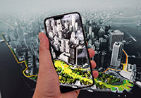
Apple is making sure you don’t get lost in over 30 airports around the world with its newest update to its Maps app. It is now easy to find a quick meal in airports like John F. Kennedy and LaGuardia in New York, LAX in Los Angeles, Toronto Pearson, or Vancouver International, among many others. You can even ask Siri to locate something for you nearby. The feature allows for real-time indoor positioning and toggling easily between floors. You can browse for everything from shops, restaurants in specific terminals or in the entire airport, boarding gates, security checkpoints, baggage claim carousels, check-in desks, etc.

Click to read more ...

Monday
Nov202017

Apple Maps lane guidance feature comes to Canada

If you use Apple Maps to navigate, you’re getting one more useful feature to use. The app now supports lane guidance here in Canada as well as in Australia, France, Germany, and the United Kingdom. Now, if you use your iPhone or CarPlay to navigate, you’ll see a set of directional arrows that at the top of the screen showing which lane you should take to complete a turn or get off a freeway. However, speed limits are still only being shown in the US and UK. The feature first came to the US and China starting with iOS 11.

Source: MacRumors

Monday
Aug282017

Apple Maps Transit coming to Edmonton, Ottawa and Quebec City

Apple Maps Transit information is available starting today to users in Edmonton, Ottawa and Quebec City.

Transit in Apple Maps launches in these three cities with local signage that carefully mimics their local public transit branding, so directions have the same icons as you’ll see on the bus or train.

In Edmonton, residents using Apple Maps can now enjoy the addition of Edmonton Transit Service; in Ottawa, the OC Ospo and in Quebec City the RTC.

Click to read more ...

Saturday
Jul082017

Apple Maps makes it easier for you to get around at the Calgary Stampede  

Whether you’re going to Calgary Stampede for the first time or an avid fan of the annual rodeo and festival, you will always need help getting there. Apple is hoping to help you avoid things like steep parking fees and even driving to the event with Apple Maps’s Calgary Transit info. It’ll let you plan your trip, get schedules, and even receive step-by-step directions to catch the CTrain or bus to head to the event. The signs you’ll see in the app are the same as the ones on the street so you’ll be able to find what you’re looking for easily. You can even let Siri guide you from one point to another. The app can even get you up-to-date information about specific transit lines and remind you about its routes and schedules.